
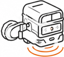
Knowing what is hidden inside a concrete structure can be crucial before any work is carried out.
With concrete radar, we can investigate the structure without breaking, drilling or otherwise damaging it. The technology makes it possible to identify and map reinforcement and other hidden objects within the concrete.
This provides a much better basis for decision-making before drilling, cutting, installing fixings, renovation and other work that may affect the existing structure.
From investigation to useful data
A radar survey involves more than simply moving an instrument across a surface.
The results need to be interpreted, positioned and presented in a way that makes the information useful for the next stages of the project.
Depending on the assignment, we can assist with, for example:
- locating reinforcement
- mapping reinforcement patterns
- detecting hidden objects within the structure
- investigation prior to drilling and coring
- data for cutting and other structural work
- surveying and documentation of results
- positioning results within the project's coordinate system
- documentation for further use in CAD and design
Why use concrete radar?
Reduce risk before work begins
Drilling or cutting in the wrong location can damage reinforcement, installations or other parts of the structure. A radar survey provides better information before work begins.
Investigate without damaging the structure
Concrete radar is a non-destructive testing method. The structure can be investigated without drilling test holes or making other physical interventions in the areas being examined.
Better data for design and planning
In older or modified structures, drawings do not always fully correspond with actual conditions. A radar survey can supplement existing drawings with information obtained directly from the structure itself.
More efficient work on site
When critical objects have been located in advance, subsequent work can be planned more effectively and the risk of unexpected interruptions can be reduced.
Documentation for the next stage
The results do not have to remain as markings on a concrete wall. When required, the information can be surveyed, documented and incorporated into the project's digital data.
Finding something is one thing. Knowing exactly where it is located is another.
Mätkonsult combines concrete radar with our expertise in professional surveying and digital documentation. This means that the results of the investigation can be placed in a wider context and, when required, linked to the building's or project's coordinate system.
Our surveyors can provide support throughout the entire process – from investigation and detection to surveying, documentation and data for further design or construction.
Contact us about concrete radar

